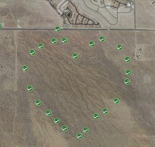
Some enterprising cache hiders will arrange a number of caches to form shapes and letters. Series like this are called geoart, here's a simple example in Google Earth:
 |
| Heartburn |
This one's called the "Heartburn Series", with individual names like "Garlic Salt", "Pickles", "Hot Dogs", etc. (One was called "Cachews" (sic)) Each icon represents a physical cache to find and sign its log. Some people take their 4x4s and quads into the desert to do this series, but Doug and Shannon and I did this one on foot. We parked on the road at the top by the unrelated cache there. The total distance we walked was only about 3 miles, and we had a great time. On the way we saw this unique little cactus, quite appropriate for the geoart we were tracing.
 |
| lonely heart |
Some geoarts can get quite elaborate Here's one up by Needles near the historic Route 66 that'd be fun to do some day:
Geocaches show up on the map as different icons, depending on what kind of cache it is (there are 13 different types). Here's a large geoart near the Mountain Home Air Force base in Idaho that uses the colours of the different cache types to good advantage:
It measures over 5.5 miles from nose tip to exhaust (as the F16 flies). And with more than 200 caches, it'd be a pretty good day's challenge.
Here's an incredible set of 1,000 near Boise, Idaho, measuring about 7 miles on a side.
Most geoart is placed in desert areas, as it's pretty hard to find large accessible open spaces otherwise. Some cachers have found a way around this, though, by publishing coordinates to trace out a design with puzzle type caches, with the actual cache for each being elsewhere. You obviously can't walk around them, though. It also poses a severe logistical challenge, as the published coordinates must be within 2 miles of the real coordinates, and real caches can be no closer together than 528 feet (0.1 mi.).
Next post, I'll show you some of the real art I've seen in the desert.


